
|
|
Ventura County
|
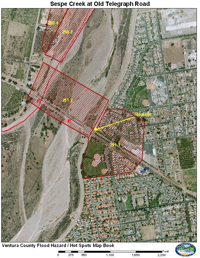
251-1 Sespe Levee Stoplogs at Old Telegraph Road
251-2 VCTC Railroad and Old Telegraph Road Bridge
The Lower Sespe Creek at Old Telegraph has a couple of problem areas. The Ventura County Transportation Commission (VCTC) owns the railroad that crosses Sespe Creek on the north side of the Old Telegraph Road bridges. The railroad bridge contains piers that can collect large debris such as logs and create a backwater issue raising the water surface elevation. The other issue is the railroad drops down over the east channel and cuts through the Corps Levee that is adjacent to the City of Fillmore. Stoplogs must be installed by O & M to provide protection for Fillmore during high flows. In 2006 additional improvements were made to enhance the stoplog structure to increase protection and decrease the potential for seepage under the stoplogs.
It is possible that very large flows can carry enough debris to damage or destroy the railroad bridge. It is also possible that the failure of the railroad bridge could cause damage or failure of the Old Telegraph Bridge immediately downstream of the railroad bridge.
Historical Data
January 10, 2005 storm produced a peak that brought the water surface elevation to just above the stoplog base elevation for the first time since construction of the levee. The USGS estimated the flows at 80,000 cfs at the upstream gage. The storm left about 6 inches of mud deposited against the stoplogs. The photo shown below shows the flow near the peak when Sespe Creek was flowing over the railroad tracks at the stoplogs on the morning of January 10, 2005.
The storms of 1978 caused damage to residences in Fillmore and resulted in the construction of the Corps levee.
The storms of 1969 destroyed the railroad bridges and damaged the Old Telegraph and the newly constructed Highway 126 bridges.
Aerial Photo and Map
Photos of Area
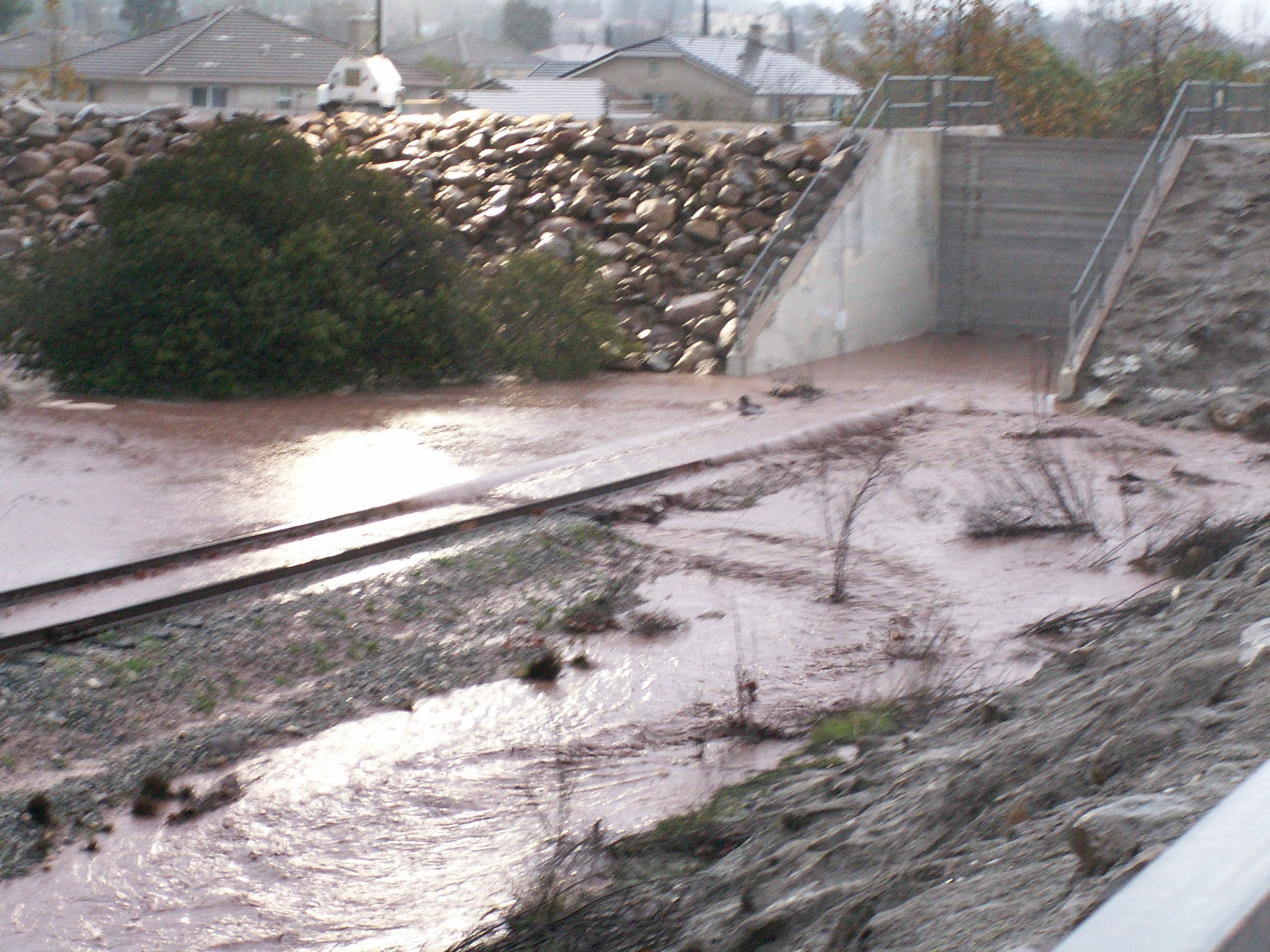
Stoplogs installed January 10, 2005 near the peak
flow of 80,000 cfs estimated from the USGS, City of Fillmore photo.
Gages
The main gage used for monitoring the Lower Sespe Creek near Fillmore is the Sespe Creek at Grand Ave (near Fillmore) USGS gage. This gage have had issues with being damaged during high flows. For this reason two sonic gages were installed downstream at Old Telegraph. The gages are installed on the downstream side of the bridges but can provide backup to the primary gage for large flows. Ratings for each sonic gage are theoretical and may be inaccurate in some flows. Further work to develop better ratings using recent measurements are in progress. The Sespe East Sonic can give an estimated water surface elevation that can be tied to the stoplog base elevation. The only issue is the sonic cannot measure the amount of backwater effect due to debris on the railroad bridge. A stream gage was also installed at Sespe Creek above Bear Creek and flows from this gage can be used along with model results to estimate the flows at Old Telegraph Road.
Special Conditions/ Issues
Since the installation of the stoplogs will require the shutdown of the railroad, the agencies that operate the railroad have to be notified prior to installation. The VCTC owns the railroad and the Fillmore and Western Railroad operate tourist trains along the route. Both agencies would like at least 24 hours notification if possible to any possible closure issues.
The Old Telegraph Road stream gages should be watched for a sudden drop in water elevation that is not seen at the USGS gage. This may indicate that debris is building up and constricting flow. Constrictions may cause the water surface elevation to rise to a level where water could pass through the levee if the stoplogs are not in place. Patrols are the only way to verify if debris issues are occurring.
Minimal Time for Implementation
Shutdown railroad: 12 hours?
Install Stoplogs: 4 hours? (more if possible)
Shutdown Old Telegraph: 30 minutes? (more if possible)
Special Conditions Procedure
Condition: Increased sediment and large debris due to the Day and Ranch fires in Sespe Creek.
Implemented: 2006; Expected expiration date 2010
Gages Used: 710, 721, 722
|
Criteria |
Value |
Issue |
Area |
Procedure |
|
Flow |
30,000 cfs |
Stoplogs |
Stoplogs |
Prepare for installation of stoplogs as precaution measure. Coordinate with OES, Fillmore, O & M, and VCTC. |
|
Flow |
35,000 cfs |
Debris at Railroad |
251-2 |
Have regular patrols monitor bridge for debris buildup. |
|
Flow |
36,000 cfs |
Stoplogs |
Stoplogs |
Stoplogs should be installed if this flow is forecasted. Coordinate with OES, Fillmore, O&M, and VCTC. |
|
Flow |
45,000 cfs |
Debris at railroad |
251-2 |
Debris may be collecting along the east end of the bridge causing higher water surface to approach the bottom of the railroad bridge. |
|
Flow |
50,000 cfs |
Stoplogs |
251-2 |
Water surface elevation may quickly approach the stoplogs if sudden buildup of debris. As a precaution the stoplogs MUST be installed before this flow value is reached. |
|
Flow |
55,000 cfs |
Railroad bridge |
251-1 and 251-2 |
Water could quickly rise and flow over the eastern part of the railroad bridge if a sudden buildup of debris occurs. Have patrols monitor for debris issues. |
Normal Conditions Procedure
Gages Used: 710, 721, 722
|
Criteria |
Value |
Issue |
Area |
Procedure |
|
Flow |
45,000 cfs |
Stoplogs |
Stoplogs |
Prepare for installation of stoplogs as precaution measure. Coordinate with OES, Fillmore, O & M, and VCTC. |
|
Flow |
50,000 cfs |
Debris at Reailroad |
251-2 |
Have patrols monitor bridge for debris buildup |
|
Flow |
55,000 cfs |
Stoplogs |
Stoplogs |
Stoplogs should be installed prior to this flow being reached or forecasted. |
|
Flow |
60,000 cfs |
Debris at railroad |
251-2 |
Water level approaches the bottom of the railroad bridge, debris may be collecting along the east end of the bridge. |
|
Stage |
TBD |
Railroad bridge (H722) |
251-2 |
Water surface elevation has reached the bottom of the east end of the railroad bridge. |
|
Flow |
70,000 cfs |
Stoplogs |
251-1 and 251-2 |
Water surface elevation is approaching the stoplogs. Stoplogs MUST be installed before this flow value is reached. |
|
Stage |
TBD (Flow about 75,000 cfs) |
Stoplogs & railroad |
251-1 and 251-2 |
Water surface elevation should be at the stoplogs base elevation and is passing over the eastern part of the railroad bridge approach. |
|
Flow |
85,000 cfs |
Railroad bridge |
251-1 and 251-2 |
Water should now be going over the eastern part of the railroad bridge. Monitor for debris issues |
|
Stage |
TBD |
Railroad bridge (H722) |
251-1 and 251-2 |
Water now going over the center part of the railroad bridge. All soffits are underwater and debris and flow may be damaging the bridge. Potential failure of railroad bridge is a possibility and if fails, could cause damage or failure of Old Telegraph Road Bridge. OES to consider shutdown of Old Telegraph Road. |
|
Stage |
TBD |
Old Telegraph (H722) |
251-1 and 251-2 |
Water surface elevation has submerged the railroad bridge and water now impacting the soffits of Old Telegraph Road Bridge. Flows and debris may cause damage to bridge. OES to consider shutdown of Old Telegraph. |
The stoplog information was obtained through observations made during the January 10, 2005 storm. The numbers for the Special Condition Procedure were established with engineering judgment in the case of a large amount of debris from the fire area start to constrict the flow under the railroad bridge. No modeling was used for these numbers. Bridge elevations were obtained from as-built plans and tied back to the sonic gage datum. Historical flood damage was obtained from VCWPD Reports.