
|
|
Ventura County
|
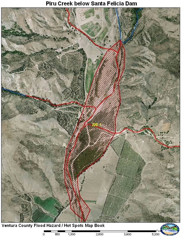
220-1 Piru Canyon Road
Piru Canyon Road crosses Piru Creek in two locations between the town of Piru and Santa Felicia Dam (Lake Piru). Piru Canyon Road is the only road that provides access to the Lake Piru Recreational area and to some remote ranches and USFS Campgrounds.
Historical Data
The February 1998 storms cause Santa Felicia Dam to spill. The area also burned in the 1997 Hopper Fire which left some large debris that went over the spillway. This debris clogged the downstream bridges directing the flow around the bridges and damaging the roadway. February 2005 had a larger spill (14,404 cfs) but without the debris. Only minor damage was reported in 2005.
Aerial Photo and Map
Photos of Area
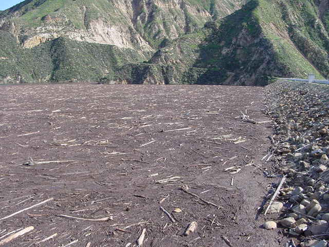
Debris from the 2003 Piru Fire covering the surface of Lake Piru as the Dam
starts to spill after the January 2005 storms.
UWCD photo.
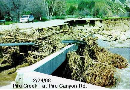
Damage to Piru Canyon Road February 1998. NWS photo.
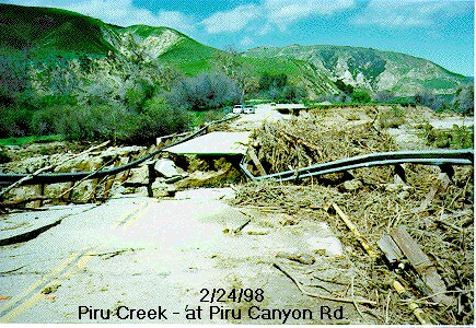
Debris and washout of Piru Canyon Road after the February 1998 storms. NWS
photo.
Gages
The main gage used for monitoring spills from Lake Piru is gage 792. This gage has both satellite (GEOS) and ALERT radio paths. The gage is a bubbler system operated by the US Geological Survey. The bubbler has three orifices to accurately measure the lake elevation when dry, half full and full. The orifices have to be changed manually.
Normal Conditions Procedure
Gages Used: 792
|
Criteria |
Value |
Issue |
Area |
Procedure |
|
Flow |
6,000 cfs |
Erosion and Flooding |
220-1 |
Watch for potential of flooding along Piru Canyon Road if debris is present on the lake and is going over the spillway. Potential for area to be isolated evacuations and closure may be warranted. |
|
Flow |
7,500 cfs |
Erosion and Flooding |
220-1 |
Warning for potential of flooding along Piru Canyon Road if debris is present on the lake and is going over the spillway. Potential for damage so roadway should be closed and anyone left should shelter in place. |
|
Flow |
8,500 cfs |
Flooding |
220-1 |
Piru Canyon Road could have washouts and flooding if debris is going over the spillway. The raod should be shutdown for safety. |
|
Flow |
10,000 cfs |
Flooding |
220-1 |
Piru Canyon Road should have flooding even if there are no debris going over the spillway. If debris is going over the spillway the road may be washed out. Travel not recommended for safety reasons. |
Data collected from observations made after the significant storms of 1998 and 2005.